Crossing the Twitya River by Bicycle
In early 1991, Jeff Hohner, a bike courier and cycling activist in Vancouver, BC, responded to an ad placed by Gordon Rennie, a wilderness adventurer and teacher in Fort St. James. Gordon was looking for partners to cycle the Canol Heritage Trail, NWT. Gordon explained that the trail was rugged but that he'd seen a tourism brochure promoting the trail for mountain biking. Jeff called his friend Richard Campbell, a computer programmer and cycling activist also living in Vancouver. The three cyclists began researching and planning an expedition...
Crossing the Twitya River by Bicycle
Jeff Hohner, 1992 / 2021
For over a day, the three of us had been nearly silent. Gordon, Richard, and I were cycling a line of muddy single-track that ran mid-slope along a mountain in Northwest Territories, Canada. Every 500 metres, a tumble of rock crossed our paths. We dismounted and pushed our bikes over these barriers of talus. Here, they were only 5 to 10 metres wide; in other places, spring creeks had torn down 100 metre wide swaths of mountain. By now, we were adept at picking a path through the boulders. We were 11 days off-road, fit and comfortable with the trail, but we still sought paths that required the least hefting of our loaded mountain bikes.
It was August 20, 1991. The day was sunny and we wore shorts and t-shirts. We were grateful for the sun because we were still many days from our first town and could not afford to waste energy; we were already stretching our rations to their limits.
We each carried about 50 pounds of gear in front and rear panniers. At outset, we carried fourteen days of food and stove fuel. Between the three of us we also carried 3 topographic maps, 2 cameras and film, and a book of Robert Service poetry, 2 stoves, 2 tents, sleeping bags/mats, clothing, 1 first aid kit, assorted bike tools and spare parts. We had already broken a rear axle, and snapped a rear derailleur, but using our spares made our load no lighter since we were packing the damaged parts out with us.
We had packed as lightly as possible. Two days ago there was snow on the ground and as I rode, I was wearing almost every piece of clothing I had packed: cycling shorts, cotton t-shirt, a set of polypropylene underwear, fleece anorak, gortex jacket, my favourite thick lycra tights, and three pairs of wool socks. One of these pairs I wore on my hands – I had sewn thumbs into the pair the day before to create a pair of mittens when the weather had turned.
We were cycling the Canol Heritage Trail – the remains of the Canol Road.
In 1942, the U.S. Army built this unlikely avenue while building a pipeline between Whitehorse, Yukon Territory, and oil fields under the Mackenzie River at Norman Wells, Northwest Territories. In 1945, the pipeline was abandoned, and nature began reclaiming the road. Within a few years, the bridges along the route were washed out. For this reason, our loads also included 200 feet of 13 mm climbing rope, 375 feet of 3 mm parachute cord, dry suits and reef boots!
Our expedition along the Canol had already taken us across innumerable creeks and several rivers. We cycled in lightweight hiking boots, but changed into neoprene reef boots when we had to ford water deeper than our ankles. Twice, we had crossed major rivers, the Carcajou and the Little Keele. At the moment we were approaching the last, and largest, major crossing of the trip, the swift and unpredictable Twitya River.
Compared to hiking, biking across a river is a much more difficult act. (At the time of our adventure, perhaps a half dozen people hiked the entire Canol Trail each year.) A backpacker may ford a waist deep river in one pass, often wrapping everything in their pack in plastic first. In deeper water they may float their packs as they ford, or even hang onto their packs and kick across the river. A cyclist must cope differently. Although our loaded bikes weighed just slightly more than a heavily loaded pack, they did not fit on our backs as securely. In water any deeper than our knees it was impossible to maintain our balance against a strong current, negotiate the uneven and sometimes invisible river bed, and balance 75 pounds on one shoulder. Although none of us had yet gone for an unexpected swim, we had learned that bike wheels and panniers were especially effective at catching the current if not kept out of the water.
When planning this trip, we learned that we would likely have to ferry our gear in several passes across at least one large crossing, the Carcajou River. For this reason we took the dry-suits. The Carcajou is wide but slow moving. Our research said it was usually possible to ford in late summer. This year, especially heavy rains in July had biased the rivers against us. However, two weeks without rain had lowered river levels significantly. We located a chest deep crossing and carried our gear across in four ferries each. On the last trip we carried our bikes over our heads.
We had also prepared for more technical crossings. The Little Keele River was deep, swift and narrow in the region that it crossed our route. A high bank on the far side of the river offered us the chance to keep our bikes out of the dangerous current altogether. We would make a Tyrolean crossing. Gordon swam across towing our light cord and climbed the steep bank. He then pulled our heavier rope across and tied it off atop the far bank. Richard and I anchored our end of the rope to a tree trunk left on the flood plain by higher waters. A mountaineer's carabiner, clipped around the rope, served as a pulley. To this we attached panniers, wheels, and bike frames, in turn. Richard joined Gordon on the far side and together they hauled our equipment up the 30 degree incline using the light cord. I remained below to load, and to enjoy the sight of our bikes being pulled along the line like laundry.
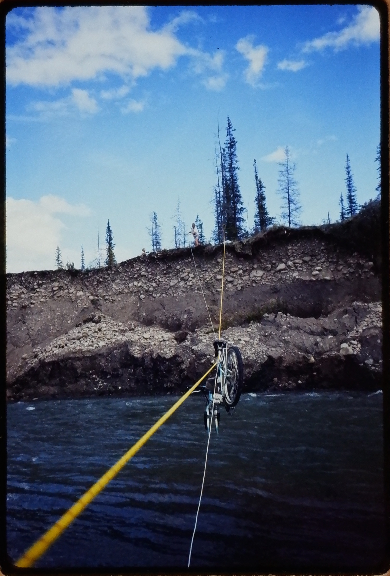
Gordon hauls a bike over the Little Keele River. August 1991. ©J.Hohner
We chose to cycle the Canol from north to south for several reasons: we knew that the road's southern sections were in better shape than its northern ones, and we wanted the psychological advantage of knowing that better things lay ahead; we wanted a quick start and a leisurely finish – an Air Canada 737 took us right to the trailhead at Norman Wells, and an Alaska Marine Highway ferry took us home from Skagway, Alaska (actually, it took us to Bellingham, Washington, a day’s ride from Vancouver, BC); and, perhaps most importantly, we knew that we would need the practice of crossing the Carcajou and Little Keele before attempting the Twitya.
All previous attempts to traverse the complete length of this trail by bike had failed. The Twitya River was the reason why. Locals told us of the cyclists who, following the road north towards Norman Wells, gave up fighting the current while rafting across the Twitya, and decided instead to complete their journey the easy way by floating the 400 kilometres downstream to the Mackenzie River and then Norman Wells. In 1988, a Canadian Army expedition almost lost one of its members to the river. This person, while swimming a line across the river in the same fashion as we had at the Keele, had been swept so far downstream by the current that they had pulled the heavier rope attached to their line into the water after themselves. The drag that this created almost drowned them. Had we brought enough line to avoid this mistake? How much had the recent rain and snow swelled the river? Today, we were largely silent as we each prepared ourselves mentally for this long anticipated challenge.
As we rounded a bend, the willows that had been thrashing our knuckles and shins thinned to reveal the most majestic mountain peak we had yet seen.
We had cycled up and down through several ranks of the Mackenzie Mountains already. The road traveled perpendicular to the range, in and out of valleys, along a traditional hunting route of the Dene people. Each fall and spring, they would travel as far as we had now come, in pursuit or ambush of migrating caribou. They would then return with stores of dried meat to the Mackenzie, by river, as those other cyclists had done.
Six days earlier, when we had mounted our first height of land, I was transfixed by a sudden panorama of range upon range of mountains. I had never seen such depth in a landscape. I felt as if I were in an airplane looking down upon it all. No doubt this sensation was heightened by the fact that we had just spent three days pushing our bikes over a boulder strewn creek bed between the awesome but confining walls of Dodo Canyon. To step out of Arizona and into Tibet was magical.
Now however, those peaks I’d seen from that lookout seemed blunted compared to the snow-capped mountains that shone in the sunlight across this valley. The edges and angles of these slopes were so distinct and regular that this range resembled a freshly sharpened saw blade. The majestic mountain that rejoiced above the rest was Mount Tigonankweine.
We were now in the very heart of the massif I had glimpsed six days ago from its edge, and this mountain was clearly the spirit that rested in that heart. Perhaps it was no accident that the road had brought us to so special a place; I imagined that the Dene must have chosen to pass this way in order to nourish themselves on this place’s power as I myself was now doing. It was at the feet of Mount Tigonankweine that we would attempt to cross the Twitya. Below us in the distance the thin ribbon of a river glittered in the sun.
We arrived at the river in late afternoon. We were confident that the sky would remain clear for the next 24 hours, so we decided to take our time planning the crossing. We wished to avoid rain not only to make the job of crossing easier, but because a heavy rain would swell the river. The Little Keele once rose 13 feet in three hours! The Twitya was already wider than we had expected; even a few feet of additional depth meant a much wider crossing. We had planned to anchor our rope across the river diagonally, and run a raft back and forth along this line. We had only enough rope for a 150 foot channel.
To charm the river and ensure that it didn't rise, we made camp on a sandy shoal near the river's edge. Within a few minutes, the ritual of homemaking was complete: our sleeping bags were lofting inside our tents, and we were sipping tea while more water boiled for our evening meal. At this time of day, we usually chatted about the day's ride and poured over our maps for clues about tomorrow's terrain. Today, however, we busied ourselves with the solitary tasks that we usually left for after dinner. We attended to the maintenance of our journals and bikes. The road did not exist on the other side of the river until we managed to cross it.
After dinner, we scouted the shore for some distance on either side of our camp. I had never seen such a volume of water flow so rapidly. The Mackenzie is four miles wide at Norman Wells, yet the Twitya seemed more powerful. I knew enough about the hydraulics of rivers to picture rows of boxcars full of tons of water rolling silently along beneath the placid but swift surface of this river. We didn't find a suitable crossing, but decided not to tire ourselves by searching for one further. The sun set at 10:30 p.m.
Earlier in the trip, when we were closer to the North Pole and the summer solstice, the sun did not set until after midnight, and it remained light enough to stroll without a flashlight until 1:30 in the morning. Dusk lingered for hours after that; in fact, the light blue arc of twilight never left the sky. It hovered above the northern horizon for the few hours that the sun hovered below it.
Tonight though, when I awoke to pee, it was very dark. There was no moon nor any northern lights. More stars shone more brilliantly than I had ever seen.
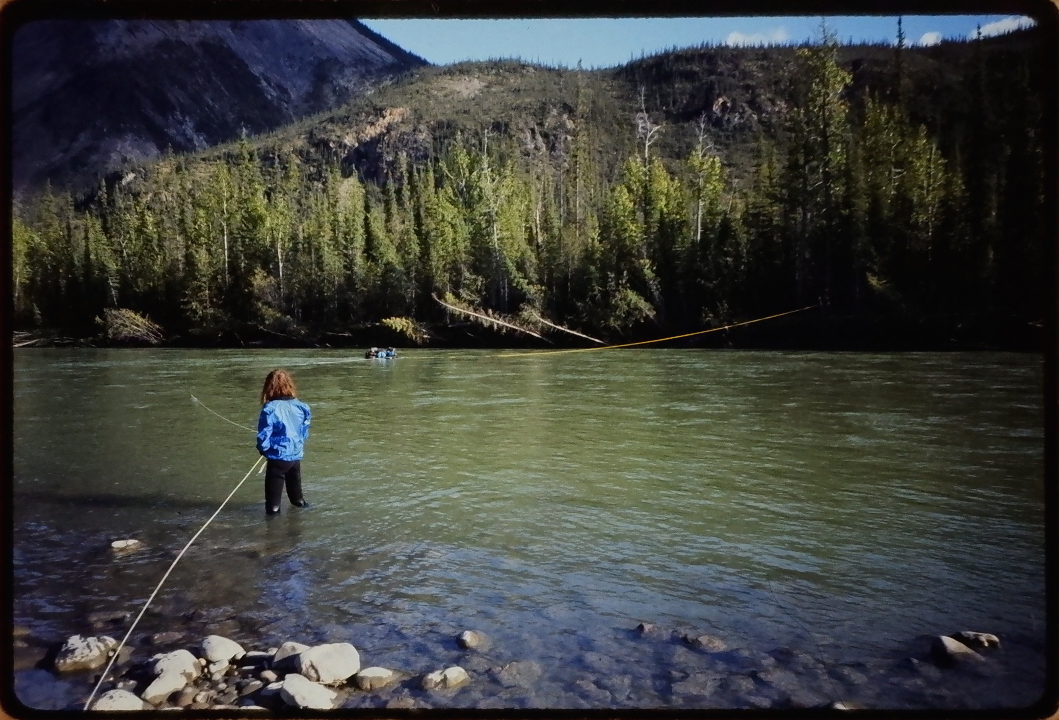
In the morning, we resumed our search at 9:00 a.m. One kilometre upstream, the river narrowed slightly. The far bank was low and the near side provided shallows in which to load a raft. This was the most suitable crossing within the several kilometres we had surveyed. We moved our equipment to this site and prepared for raft making.
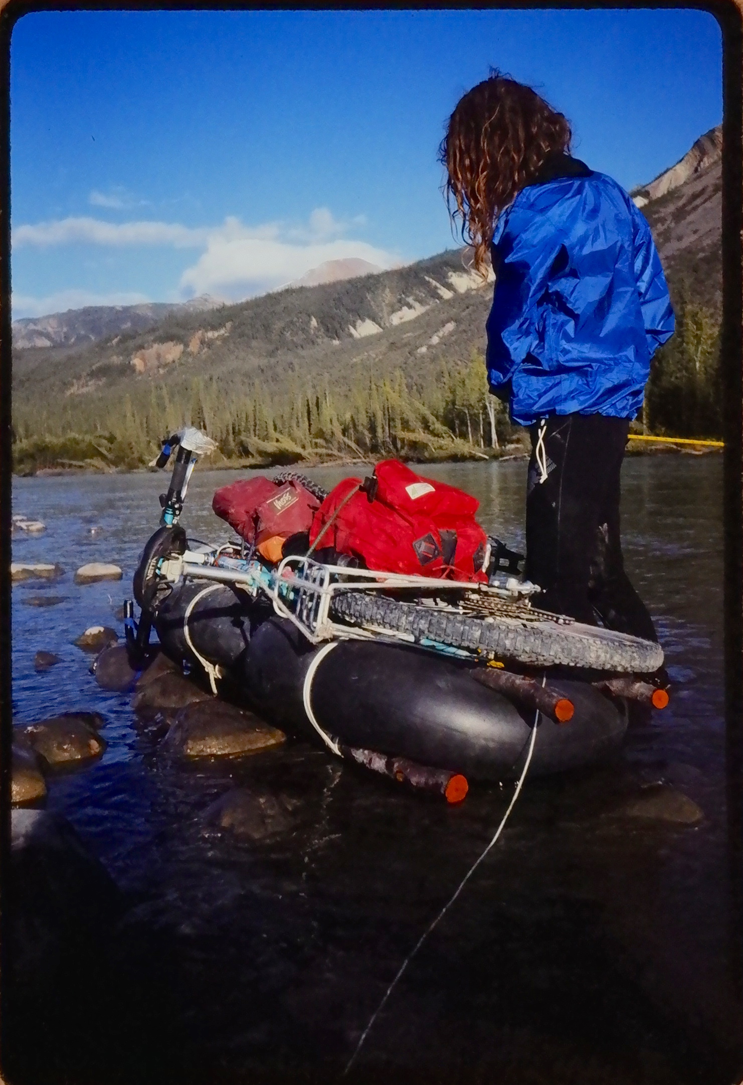
We had carted two automotive inner tubes the 200 kilometres we’d come so far for the purpose of building a raft. We now inflated them with our bike pumps, chose four stout, wrist-sized poles from the beached flotsam, and lashed these to the tubes in pairs, sandwiching the rubber donuts, top and bottom. This unlikely hybrid of industrial and wilderness materials resembled an elaborate cushioned stretcher. It was the size of a bicycle laid on its side. Would it be stable in the water, I wondered to myself? Or would it swamp and leave us stranded without crucial gear?
It was now 1:00 p.m. Gordon, still our strongest swimmer, donned a dry suit and buckled a quick-release belt around his waist. In an emergency he could use this to free himself of the line he would tow across. We carefully laid out this line to ensure it would pay out without tangling. He crossed.
The river did not carry him as far downstream as we had thought it might. He walked back up the far bank passing the cord from hand to hand around trees that blocked his way. I wished him a good grip because the current tugged forcefully at even this fine cord. After an exchange of hand signals, he began to haul across the heavier rope that we planned to anchor on both sides of the river as a zip-line. Richard paid it out until he held its end and stood as far into the river as the shallows would allow. I had miscalculated. The rope wasn't long enough!
My mind raced. With Gordon on the other side, we were committed to continuing. Yet we didn't have the means to do so. The sounds around me faded to silence. Zip-line, Z-drag, prusik and figure-eight knot. I tried to calm myself by reviewing all the techniques I had studied in preparation for this crossing but which I knew were now useless. They all depended on more rope, and we had none. Time was running out. I could see the sun moving through its arc overhead. We would have to haul the raft back and forth without the security of a fixed line. The heavy line would be strong enough to tow the loaded raft in one direction but was the light line strong enough to haul it back? My fingers were stiff and impatient with adrenalin as I fixed both lines to the raft.
Richard braced the rope against the current while I bungeed panniers to the raft. I carefully balanced the load so that slightly more weight rode aft to prevent the current from grabbing the nose of our craft and tipping it.
As the first load of panniers slowly crossed the river, it seemed to me that the far shore retreated from us in the same elastic way that the rope bowed in the current. It took several minutes of hauling for Gordon to move the raft across the river. When it was across, he jumped into the waist deep water to unstrap our gear and toss it four feet up onto the bank. He had to manage this while bracing the raft against the bank. The river's channel left him very little room to work. It was a difficult task for one person and I considered joining him to help with the next load.
Gordon (concealed by shadow and forest) hauls a raft load across the Twitya River. Richard pays out return line in the foreground. August 1991. ©J.Hohner
Towing the raft back, however, required four hands to grapple the thin and slippery cord. The raft acted like a large stubborn dog. The more we pulled it (and the more rope we pulled into the river after it) the more it resisted. Nonetheless, the cord held. This time, we placed a bicycle on the raft. As I strapped it down, it bobbed in the water atop the inner tubes like a sheep protesting being thrown on its side for shearing. I reassured it with a pat and gave Gordon the signal to start.
The raft crossed a second time successfully.
Each time it crossed, I anxiously studied the behaviour of the loaded raft to better estimate its maximum capacity. During the long helpless intervals when the raft was out of our immediate control, I imagined physics problems: "On a swift northern river, you and two other cyclists construct a raft of buoyancy B to transport a total mass M perpendicular to a current of force F using an untethered line. Calculate the minimum number of ferries necessary to transport this mass without capsizing the raft and losing your gear and bicycles."
As hard as I thought, however, my math failed me. There was no solution to this problem but the empirical one at hand.
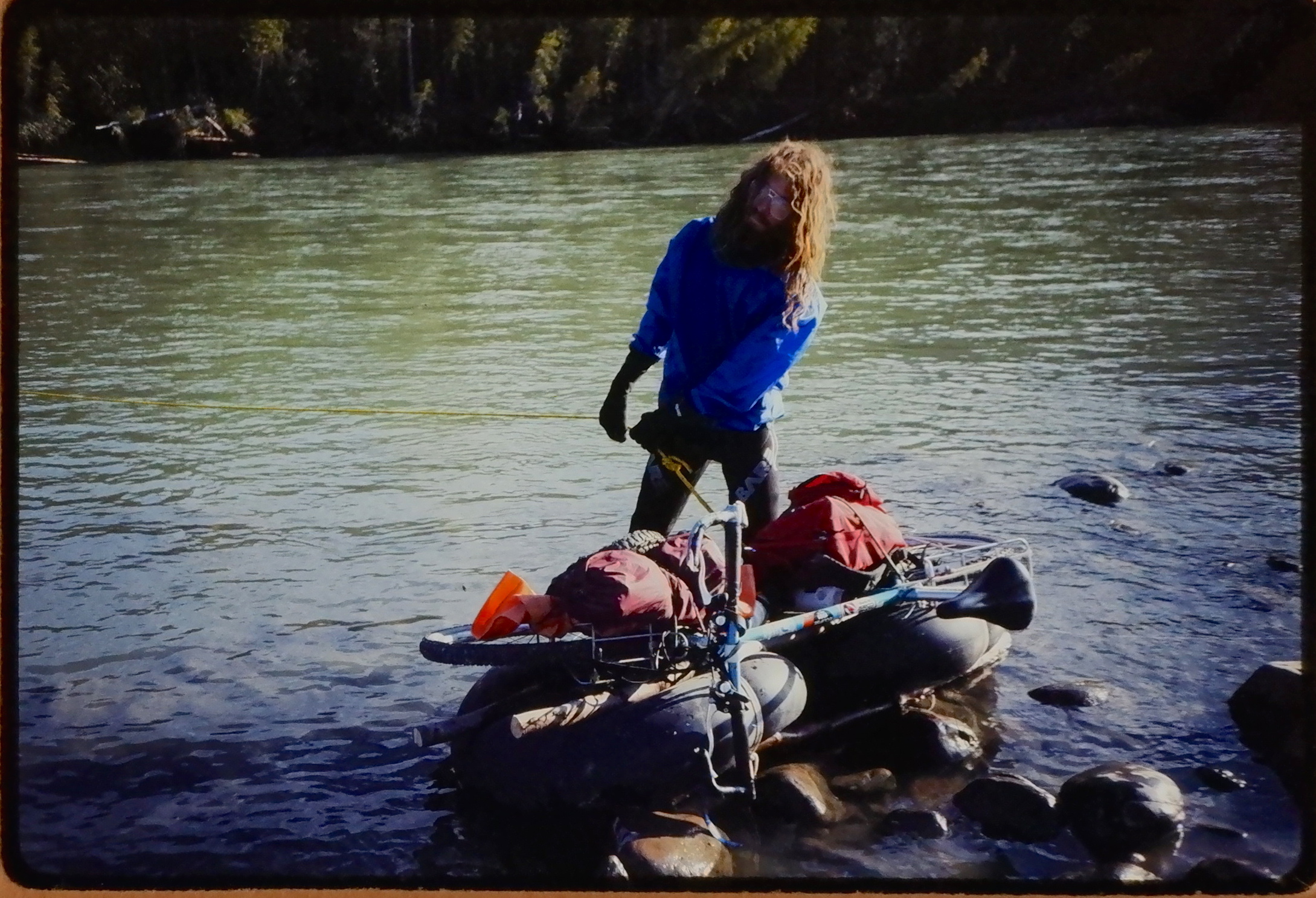
Richard braces our raft against the shore of the Twitya River. August 1991. ©J.Hohner
It took 5 trips. All of our gear made it across as dry as it had started! Richard had been standing in the water for over an hour. On the last crossing, he and I rode the raft over like sultans on a magic carpet. All three of us were elated. We gave each other hugs, saluted the far shore goodbye, and hollered with joy in the direction of the trail to come.
We carried the raft triumphantly over the muskeg in search of the road, then I cycled with it recklessly balanced over one shoulder to the end of the road on this side of the river. In one of the huts located there, we left the raft, our rope, and one of our bike pumps for someone else to use. It was almost 4:00 p.m. We were too talkative to bike, so we made dinner and went over the events of the last few days in detail.
Five days later, we crossed the continental divide and entered the Yukon. Here the road became young again. We cycled ecstatically past road signs and over bridges! For 60 kilometres we enjoyed a decrease in elevation and a tail wind. I felt like a Norse god on two wheels descending from his mountain home. Indeed, we plundered the first civilization we came upon. Stopping at a mining camp, Gordon had his wits about him when he was asked if there were anything we needed. A kilometre down the road, we settled into the seats of one of the countless 60 year old construction vehicles abandoned along the Canol, and shared a six-pack to celebrate the finish of the Canol Heritage Trail and the start of the Canol Road.
We had covered 393 kilometres of abandoned road, single-track and creek bed in 16 days. Where the road still existed, it was in excellent shape. Often its original hard packed, crushed stone surface was still intact. In other places, it had been weathered away to reveal a slightly coarser but still ridable surface. However, where the road had been built along a water course, as it frequently had been, it had completely vanished. Approximately 20% of the Canol in NWT is washed out. (* An observation from 1991. Trail conditions have certainly changed.)
In contrast, Yukon Territory has maintained the Canol as a summer use road. This Canol would lead us quickly to the tiny village of Ross River, for showers, pizza and more beer. From there we would continue south to Johnson's Crossing at km 857. This was the end of the Canol. Then it would only remain to cycle the asphalt of modern highways to Whitehorse, Carcross, and the Pacific Ocean at Skagway. At that point my cyclometer would register 1195 kms and my journal would contain 28 days of entries.
Traveling the Canol by bike taught us what others have known for thousands of years: that the most efficient ways to get around the north are by canoe and by foot. Fate, however, made us cyclists, and pride in this fact made us foolhardy. From the Mackenzie to the Pacific by mountain bike, Mac-Pac ’91, as Gordon had coined it, tested our chosen mode of transportation to its limits. Yet despite severe conditions for cycling, and formidable obstacles for any mode, we made it!
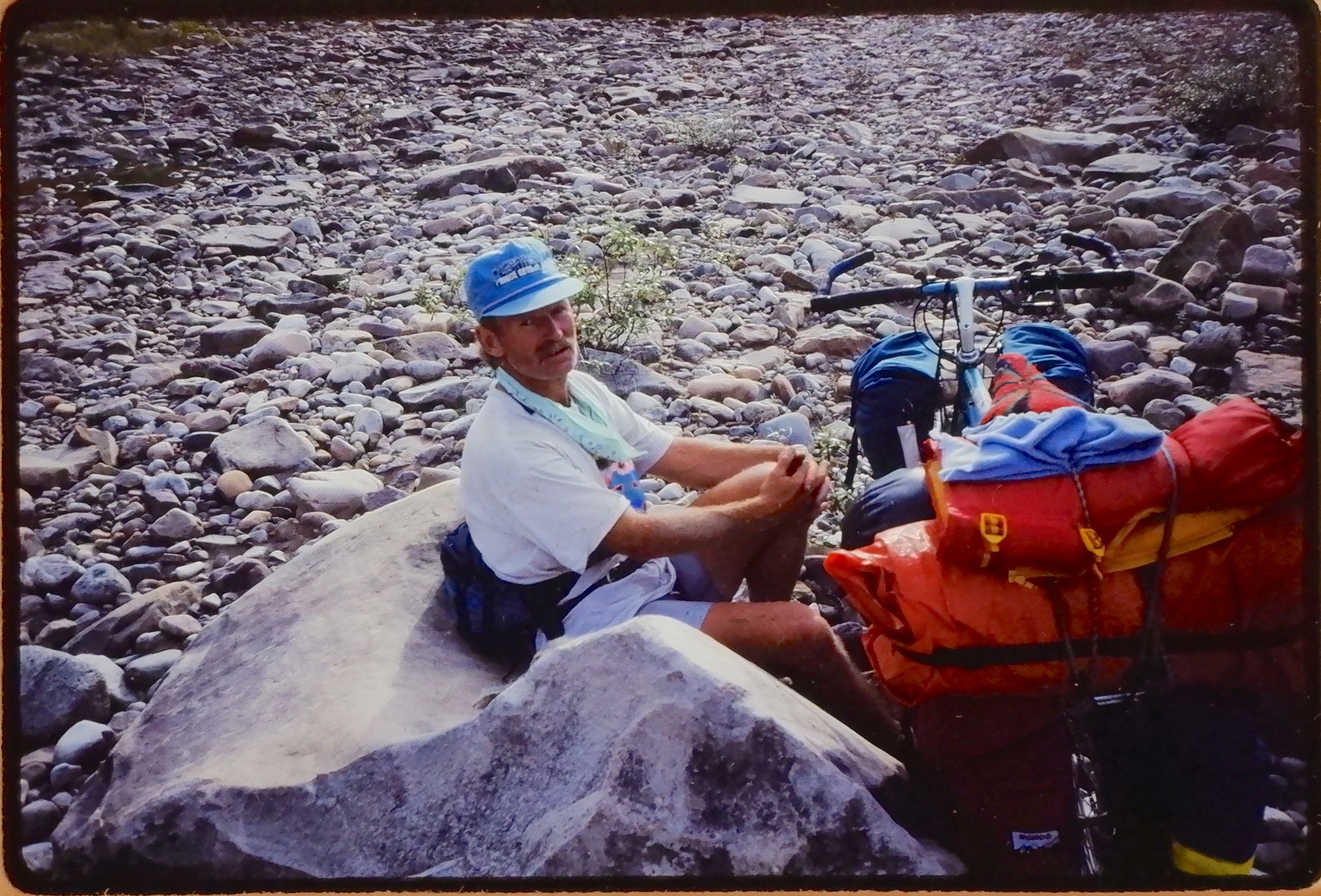
Richard Campbell at the Twitya River, Northwest Territories. August 1991.
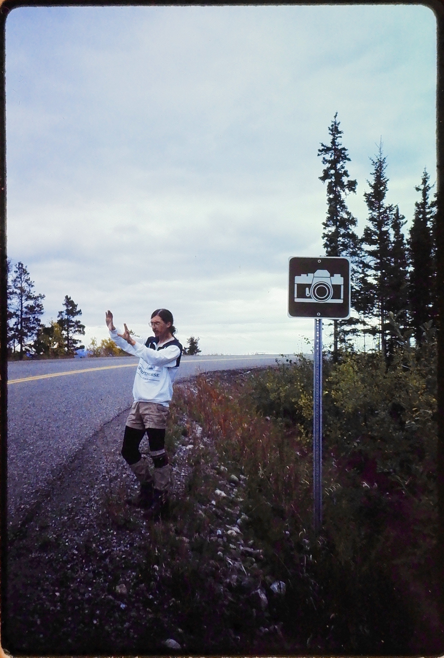
Jeff Hohner on the Alaska Highway, Yukon Territory. September 1991.
Gordon Rennie in Dodo Canyon, Northwest Territories. August 1991.